Research
Identifying Flood Debris Drivers and Generation through Machine Learning & Remote Sensing Technologies for Disaster Debris Field Data Collection and Operations
Most of the disaster debris prediction and estimation models currently used in practice are off by orders of magnitude due to their generality and inherent uncertainty and no methods exist for urban flooding. The focus of this study is to employ both unsupervised and supervised machine learning techniques to understand the relationships and drivers influencing flood debris quantities across a region using a post-disaster waste dataset acquired in Beaumont, TX, after Hurricane Harvey. The results of this study will guide flood debris predictions and provide a data-driven methodology for forecasting debris from future flood events.
The current knowledge gap on post-disaster waste quantities can be addressed by using remote sensing technology to quantify disaster debris promptly following a hazard. This study aimed to demonstrate and compare multiple remote sensing tools available for quantifying disaster debris using post-disaster data collected in Grand Isle, LA, following Hurricane Ida. A framework was developed to evaluate remote sensing technologies and their efficacy in debris management, which will assist debris quantification efforts and decision making for disaster waste managers.
Funding Agency: Graduate Research Fellowship, NSF Rapid
Student: Jasmine Bekkaye
Improving the Design and Construction Practice of Marsh Creation Projects
ACTIONS
Dredging is the primary driver of costs in marsh creation and restoration projects, accounting for around 60% of the total cost. A reduction in construction costs, by even 5% would result in savings of hundreds of millions of dollars, when considering the hundreds of thousands of acres presented in the Louisiana Coastal Masterplan. A combination of CPTs, UAV surveys, and laboratory tests will be used to determine the total consolidation the dredge sediment will undergo throughout the project’s service life.
Funding Agency: RESTORE COE
Student: Daniel Gallegos
Seismic Analysis of Chenier Plain Calcareous Soil in Coastal Environments
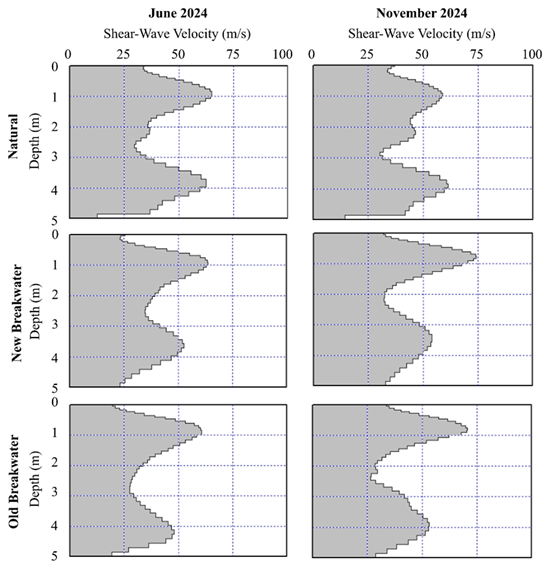
There is an urgent issue of coastal erosion in Louisiana’s Chenier Plain, a region highly vulnerable to shoreline retreat and storm impacts. While current geotechnical methods effectively characterize siliceous sandy soils, knowledge gaps persist in understanding calcareous, shell-rich sediments that exhibit unique mechanical behaviors under cyclic loading. To bridge this gap, an integrated geophysical framework employing Multichannel Analysis of Surface Waves (MASW), PANDA dynamic cone penetration, and three-component seismic monitoring was applied to evaluate the erodibility and cyclic response of calcareous coastal sediments. The proposed approach provides high-resolution, spatially
distributed soil characterization critical for predicting storm-induced responses and understanding current interactions between these soil properties and erosion mitigation strategies.
Funding Agency: National Science Foundation (NSF)
Student: Cyrus Bahman
Automated and Robotic Inspection of Flood Control Systems
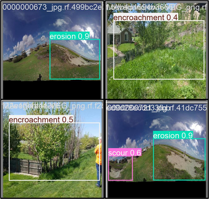
Levees are vital infrastructure for flood protection, yet traditional inspection methods are labor-intensive, infrequent, and subject to human error, leaving communities vulnerable to undetected structural defects. Recent advances in remote sensing and deep learning offer promising avenues to modernize levee monitoring, enabling more frequent, accurate, and scalable assessments. This study proposes a deep learning framework utilizing high-resolution 360-degree streetview imagery supplemented with images obtained from literature and technical reports to automate the detection of geotechnical defects in levee systems. The current leading research in the world of levee inspections uses drone-based imagery, which is notably expensive, time consuming, and requires expertise which likely does not currently exist in agencies responsible for levee inspections. By leveraging deep learning for image analysis after collecting high volumes of streetview imagery, this research aims to address these limitations and enhance real-time hazard detection for levee maintenance. The proposed methodology is evaluated on a dataset of georeferenced levee imagery, with performance assessed against established benchmarks. The results demonstrate the model requires more training data but suggest that the deep learning approach can be feasible for analyzing this data. Although the overall mean average precision (mAP) of this model is 0.433, the value for the individual class which has the highest mAP is erosion, recording one which is well over 0.8, is the class with the most images. It can be assumed that if enough data is obtained for the remaining defect classes, the accuracy will improve to an acceptable value.
Funding Agency: USACE ERDC
Student: Cyrus Bahman
Tensile Strength and Root Porosity
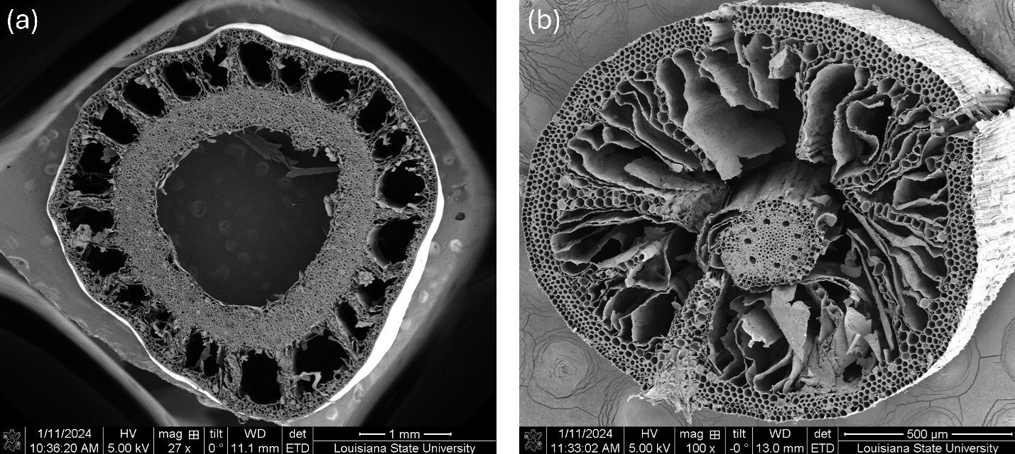
Root tensile strength is a critical parameter that determines how effectively vegetation anchors soils against hydrodynamic and climatic stresses. In coastal marshes, tensile strength directly influences resistance to uprooting during extreme events and contributes to the persistence of marsh edges. However, tensile strength is closely linked to anatomical traits such as root porosity, creating trade-offs between structural strength and functional efficiency. This research examines these biomechanical trade-offs to better understand how vegetation traits control both ecological function and geotechnical stability.
Funding Agency: National Science Foundation (NSF)
Student: Mohamed Hassan
Outcomes:
Hassan, M. O., Jafari, N. H., Rovai, A., & Twilley, R. R. (2025). Biomechanical trade-offs between root tensile strength and porosity in coastal marshes. JGR: Biogeosciences, under review. (Preprint available at Authorea: doi.org/10.22541/essoar.175769312.29748207/v1).
Coastal wetlands are vital ecosystems that enhance water quality, support biodiversity, sequester carbon, and buffer coastal communities from hurricanes by reducing waves and storm surge. Understanding their resilience requires linking root productivity and turnover to eco-geomorphic processes and transient disturbances.
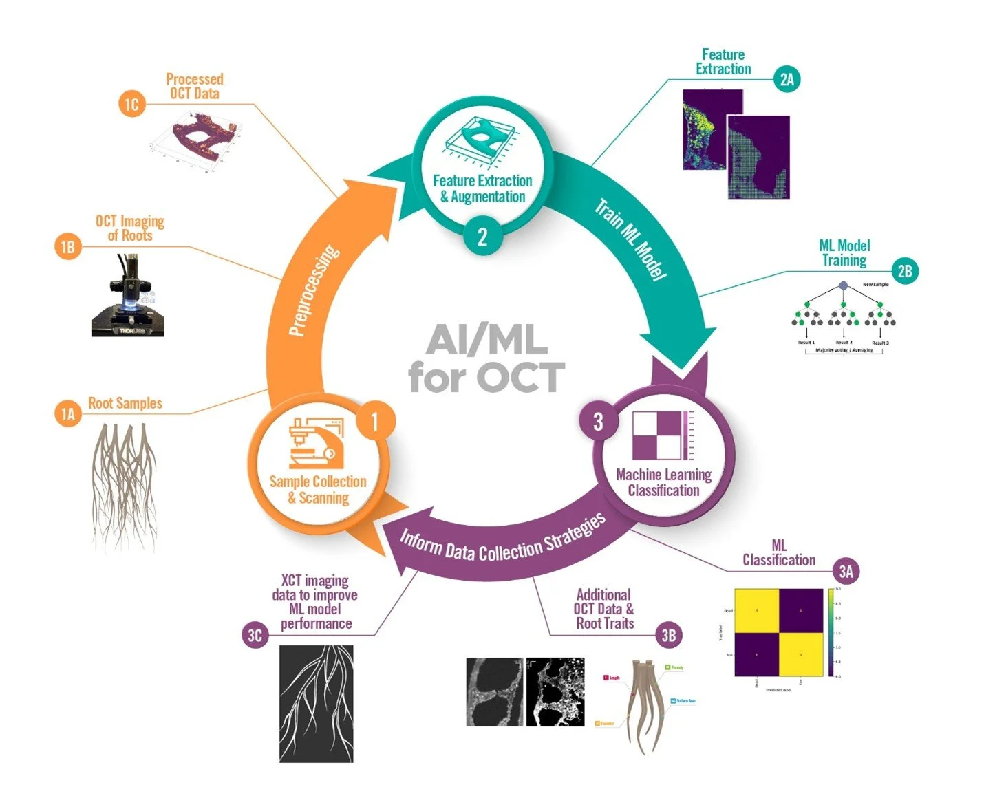
This project integrates optical coherence tomography (OCT) and micro X-ray computed tomography (XCT) to examine live, dead, and decaying roots. The objectives are:
Perform OCT and XCT scans on individual roots.
Develop and validate AI/ML models to fuse multimodal, multi-resolution datasets for segmentation of roots, architecture, pore structure, and sediment density.
This work is conducted through a collaborative partnership with the Environmental Molecular Sciences Laboratory (EMSL), a DOE Office of Science user facility at the Pacific Northwest National Laboratory (PNNL).
Fusion of X-ray Computed Tomography and Optical Coherence Tomography Techniques for Root Analysis Across Coastal Environmental Sites
Funding Agency: National Science Foundation (NSF)
Student: Mohamed Hassan
Outcomes:
Hassan, M. O., Truong, A., Mudunuru, M., Butler, L. G., Rovai, A., Larimer, C., ... & Jafari, N. H. (2025). From pixels to patterns: Coupling Optical Coherence Tomography and machine learning for monitoring coastal wetland root systems. Science of The Total Environment, 999, 180315. doi.org/10.1016/j.scitotenv.2025.180315
Hassan, M. O. et al. (2026). Optical coherence tomography analysis of wetland root systems across contrasting environmental settings using 3D convolutional neural networks (in progress).
Evaluation of the Distribution and Geotechnical Properties of Outer Continental Shelf (OCS) Sand Resources and Coupled Environmental Responses to Dredging
Focusing on mud-capped dredge pits (MCDPs) in the Northern Gulf of Mexico, this project examined how dredging and sand mining affect seafloor stability. Vibracores were retrieved from dredge pits and surrounding walls, complemented by geophysical surveys to map sub-bottom stratigraphy. The geotechnical characterization revealed weak, underconsolidated infill sediments, highlighting potential instability during storms and long-term consolidation behavior. Results support coastal restoration planning and BOEM resource management.
Funding Agency: USCRP
Student: Omar Alawneh
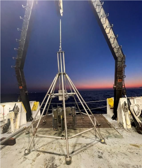
This project evaluated the geotechnical behavior of sediments in the Mississippi River Delta Front (MRDF) to assess risks of seafloor instability. Sediment cores were collected and analyzed to determine strength, consolidation, and erosion properties. Instrumentation was deployed in East Bay, LA to monitor hydrodynamic parameters, linking laboratory properties with field pore-pressure and wave measurements. This integration of core testing and in-situ data provides new insights into mechanisms of offshore slope failures.
Offshore Analysis of Seafloor Instability and Sediments (OASIS)
Funding Agency: National Science Foundation (NSF)
Student: Omar Alawneh
This collaborative effort integrates field sampling, geophysical surveys, and numerical modeling to assess hurricane-induced hazards to natural and engineered coastal systems. Gravity cores were collected across the Chenier Plain, LA and logged with multi-sensor core logging (MSCL) to identify storm layers and seabed changes. Coupled with geophysical surveys, the findings provide critical data for modeling hurricane-driven sediment transport and seabed response, informing risk assessments for erosion and shoreline treatment.
Rockefeller Wildlife Refuge is undergoing active shoreline retreat and marsh-edge erosion. This project seeks to explain the ongoing erosion by linking the geotechnical properties of the shell-hash layer (gradation and sorting, fines content, breakage/shape, packing/void ratio, and bonding) to the critical shear stress for incipient motion and erosion (τc). The goal is to establish a clear, predictive relationship between shell-layer properties and τc, identifying erosion thresholds and guiding protection design and maintenance.
Collaborative Research: Integrated Numerical Modeling and Field Observations of Hurricane Impacts to Natural and Hybrid Infrastructure & Shell-Hash mechanics at Rockefeller Wildlife Refuge
Funding Agency: Bureau of Ocean Energy Management (BOEM)
Student: Hamed Nasiri, Omar Alawneh
Outcomes
Nasiri, H., Jafari, N., Alawneh, O., Chen, Q. and Cadigan, J.,2025. Geotechnical Evaluation of Overwash Chenier Beach Deposits, Engineering Geology (Submitted)
Advancing Marsh Creation Monitoring with Instrumented Settlement Plates (ISPs)
Funding Agency: Restore COE
Student: Omar Snosi
Outcomes
A validated framework for interpreting ISP datasets across multiple projects.
Field-tested sonar sensors for mudline tracking.
A web platform for integrating ISP, sonar, and construction data.
Peer-reviewed publications in journals such as ASCE Journal of Geotechnical and Geoenvironmental Engineering and Coastal Engineering.
Workforce training for graduate students in coastal geotechnics, instrumentation, and data science.
Current practice calculates target effective stress (σ′) using boring data and assumes that post-construction ISP readings will match long-term project design values. However, this assumption has never been comprehensively validated. In this research, ISP datasets from multiple marsh creation projects are compiled and analyzed to examine the efficacy of σ′ as a construction metric. These time series are compared against daily dredging reports, foundation settlement, and laboratory samples to evaluate whether observed ISP trends align with expected geotechnical behavior of placed slurry. While ISPs track total stress and pore pressure, they cannot identify the evolving mudline where water decants, and self-weight consolidation begins. To address this gap, the team is developing a low-cost, portable sonar sensor system.
Anticipating Threats to Natural Systems (ACTIONS)
Our team’s focus within the ACTIONS project is Marsh Geomechanics, which examines how root systems influence the stability of coastal wetlands. Wetlands act as natural barriers that help protect military installations and coastal communities from intensifying hurricane storm surges, waves, sea-level rise, and climate extremes such as heavy rainfall, droughts, freezes, and heat waves. However, these systems are also vulnerable to marsh-edge erosion from wave attack, uprooting during hurricanes, and long-term collapse under rising seas. To address these challenges, we investigate the biomechanical contributions of vegetation through two complementary research objectives.
Funding Agency: DOD, EMSL, ANL
Student: Mohamed Hassan
Root-Driven Shear Strength in Coastal Wetlands
Funding Agency: National Science Foundation (NSF)
Student: Mohamed Hassan
Outcomes
Hassan, M. et al. (2025). Application of Direct Shear Testing to Assess the Influence of Mangrove Root Structures on the Shear Strength of Coastal Wetlands. Geo-Extreme 2025.
Hassan, M. et al. (2026). Shear Behavior of Mangrove Soils in Louisiana and Texas: A Dual Approach Using Large-Scale Direct Shear Testing and In-Situ Cone Penetration Testing. Geo-Congress 2026.
Beyond tensile strength, the reinforcing effect of root systems on soil shear strength is vital for resisting erosion and enhancing wetland resilience. To investigate this, two mangrove and two saltmarsh sites were selected in Atchafalaya, LA; Port Fourchon, LA; Galveston, TX; and Apalachicola, FL. At each site, large-scale direct shear tests and in-situ cone penetration tests were conducted, along with measurements of belowground biomass and necromass, to assess soil resistance and vegetation reinforcement mechanisms.
Harnessing Machine Learning for Railway Damage Assessment and Prediction
Railway systems in coastal regions face distinct challenges due to environmental factors such as coastal erosion, hurricanes, and rising sea levels. Coastal erosion undermines railway embankments, resulting in structural instability and heightened maintenance costs. Hurricanes and storm surges present further risks, with high winds and flooding threatening to damage rail infrastructure, disrupt services, and compromise public safety. To address these vulnerabilities, railway systems in these areas require advanced engineering solutions capable of mitigating the effects of extreme weather events while ensuring operational continuity. By leveraging machine learning techniques to assess and quantify damage to railway infrastructure
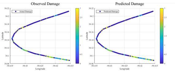
following major storm events, valuable insights can be developed to inform the design and maintenance of coastal railway systems. By collecting and processing data on railway characteristics, storm events, and resulting damage, a predictive machine learning model was developed to estimate future storm-related damage. The model achieved an accuracy of approximately 84%, demonstrating its potential for practical application. Additionally, three hypothetical scenarios were developed to evaluate the model's performance by varying key input parameters.
Funding Agency: National Science Foundation (NSF)
Student: Cyrus Bahman
Machine Learning Based Organic Soil Classification Using Cone Penetrometer Tests & Predicting Inorganic and Organic Soil Unit Weights from Cone Penetrometer Tests using Artificial Neural Networks
Soil classification methods currently rely on soil borings or cone/piezocone penetrometer tests (CPT/CPTu). Literature provides several methods that classify soils based on two parameters (typically tip resistance and friction sleeve/porewater pressure) obtained from CPTu data, defining a Soil Behavior Type (SBT). However, these methods face challenges in reliably classifying certain soils, such as organics. Robust and complex analyses are required to classify organic soils accurately. In this study, a Random Forest (RF) based method is developed to predict the presence and depth of organic soils. The RF model utilized features from CPTu soundings including tip resistance, sleeve friction, and pore pressure. The true location of organics, derived from index properties obtained from soil borings, served as the model’s outputs. Unseen CPTu data was used to predict organic soils throughout the entire project alignment, serving as validation for the model. The model achieved an F1 score of 0.89. Settlement analyses were conducted to evaluate the practical implications of the model’s predictions on levee fill costs. The RF-based model yielded settlement predictions that closely matched those obtained through boring predictions. In contrast, traditional classification methods underestimated settlements, resulting in lower estimates for levee fill costs.
This study harnesses Artificial Neural Networks (ANNs) to predict saturated unit weight (γsat) values utilizing Cone Penetration Tests (CPT) parameters and geologic features, providing a site-specific geotechnical solution. Current CPT-based models overestimate unit weight values for organic soils. Although methods to predict unit weight using machine learning algorithms such as ANNs exist, this study aims to improve the prediction accuracy of organic soils by incorporating additional parameters. The ANN model developed herein, consistently achieves low normalized mean absolute errors (< 3%) and high coefficients of determination (R2 ~ 0.90) across diverse soil types, including organics and inorganics. The practical implications of more accurate γsat predictions in slope stability analyses, particularly for levee embankments exemplified by the West Shore Lake Pontchartrain (WSLP) project, are also assessed. The study emphasizes the pivotal role of accurate γsat values in these analyses, highlighting the ANN model's advantage of conducting stability assessments along the entire levee alignment from CPTu data, in contrast to traditional practices confined only to soil boring locations.
Funding Agency: CPRA, SEA LA GRANT
Student: Omar Ulloa
Our team’s focus within the OASIS partnership is Seafloor Geohazards, examining how sediment fabric, gas-charged layers, and wave-driven pressure gradients govern instability across the Mississippi River Delta Front (MRDF). The MRDF hosts critical pipelines, platforms, and historic wrecks; mass wasting, mudflows, and seabed creep threaten offshore safety, resource development, and cultural resources. To address these risks, the effort integrates regional seafloor mapping and coring with laboratory geotechnics, in-situ sensing, and coupled numerical/machine-learning models to identify preconditioning, quantify triggers, and deliver updated hazard forecasts for infrastructure and archaeology.
Offshore Analysis of Seafloor Instability and Sediments (OASIS)
Funding Agency: Bureau of Ocean Energy Management (BOEM)
Student: Hamed Nasiri, Omar Alawneh